

| Home | GIS for you | Useful GIS | About us | Contact us |
![]()
| GIS for You | GIS Applications | Watershed GIS |
| click here |
Watershed GIS
![]()
Watershed GIS:
Watershed management is successful only through a proper Watershed Planning. GIS based watershed planning is the buzz-word now. All Action Plans essentially need GIS. GIS based watershed management not only tags fool-proof Planning, but it also helps in Watershed monitoring in the long run. The GIS for watershed or Watershed GIS as it could be called, is simple and easy to perform. All you need is right watershed guidelines. .
Watershed - in nutshell:
Watershed is all about an area, a land surrounded by hills/elevation whereby the water is shedded to the valley/lower elevations. The water of the area through small nallahs comes to main drain and this ultimately flows out.The entire area is delieated naturally by ridges/higher elevation places. Thus it is a well demarcated geographic unit on land.
 |
As per the standard Watershed Guidelines, there are several classifications like the smallest being the Micro-Watershed, medium ones being Mili-Watershed and so on. It is a miliwatershed that is normally taken as a workable unit to carry out watershed management.
It may comprise of many microwatershed areas. In geographic terms - a miliwatershed is about 5000 Ha area and microwatershed is about 500 Ha area. |
Action Plans:
The treatment plans or the Watershed Action Plans as these are normally called are prepared for individual Microwatersheds. The process of action plan making combines the field data collection and mapping, followed by the analysis to understand the problems of area as also the potential. And then, the treatments are recommended by the Technical teams. The treatments may be for the requirement of Water conservation, Water harvesting, Soil conservation and so on. GIS based watershed action plans are supposed to be more dependable. The watershed guielines also now emphasise on GIS based watershed management. Efficient methodology for watershed planning is also discussed on this webpage.
GIS Maps are helpful :
Preparation of an Action Plan for watershed is a fairly technical process and requires lot of information in hand, using which the analysis should be performed. The recommendations about the treatment measures have to be based on judicious decisions, otherwise, the impact of the intervetion after implementation in the area would hardly have any result. The treatment selection and proper site selection is the crux of the watershed management, and this may be easily achieved with a micro-level Watershed GIS.
If we observe the routine practices adopted usually by Implementing Agencies, there is lot of stress on field level surveys. _ What these present methods end up with is - compiling large amount of data as text and numbers. Most of these unfortunately ignore the other easier options of using available information and detailed maps. |
||||
|
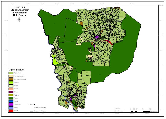
On the contary the watershed GIS or GIS based watershed action plans ensure that each and every information is referenced and presented well on village level maps [cadastral maps] where from Khasra specific action plan can be made. It is very essential to understand that it is only the GIS based Watershed Maps which rightly present the picture of current situation and the requirements of the area. Maps may help to show what and where the problem is and where treatment activity be undertaken and what would be impacted area.
Once the layers of all kinds of Maps - the thematic maps, about the area for basic information and that of the requirements are readied and once these Maps are superimposed over each other, only then can somebody state as to what treatment is desired at a site- otherwise not.
 |
 |
 |
Use of Maps to produce Fool-proof Action Plans :
![]()
Let us put it in simple terms like this:
| - | One should collect the data in forms/schedules from fields, but also try to Map them. |
||
| - | Make as many maps as possible, say Landuse, Land ownership, Drainage, Slopes, Soil, etc. and if possible, take even Geology, Ground-water, Hydrology etc. |
||
| - | Superimpose most of them. And ultilmately make few integrated Maps. |
||
| - | Analyse the information about every problem area carefully - say, why soil erosion is increasing, why ground water table is falling, why the water runs away from main nallahs or old-tanks. Mark them on Maps also. Also mark on the same Map the requirements that the villagers have. |
||
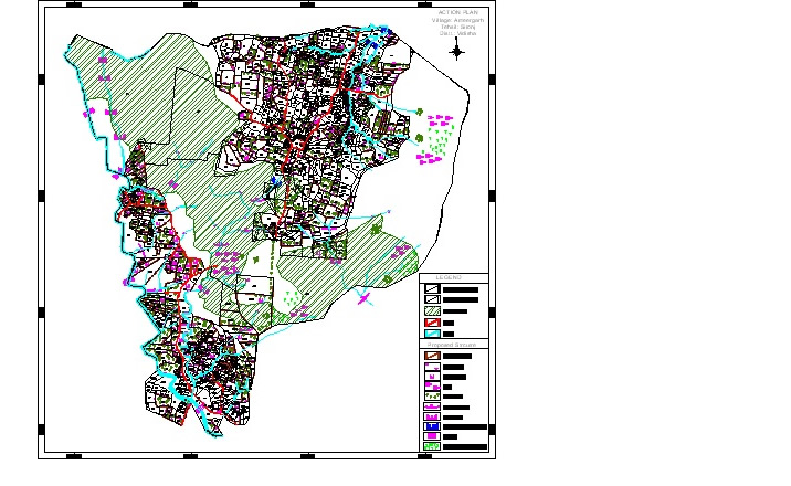
| - | After this, start planning about treatments for these problems and for meeting the requirements. With the help of background Maps of various relevant themes, it becomes quite easy to approve as to which areas would be suitable for tubewells/wells, where the vegetation should be increased, where planatation must be taken up, where the water should be stored through dams, whwre the soild contour trenching should come up. |
In nut- shell, quite easily now you may be able to give the Recommendation of Treatment Activities and define the most suitable Site for each treatment. That's a perfect Action Plan, which has sufficient justification with the help of the maps, about each treatment work and sites choosen therefor.
_____________________________________________________________________________________________
![]()
Additional Useful Reading:
![]()
A small note on Watershed [http://www.westgodavari.org/Neeru Website/watershed.htm]
McKean County Conservation District - Water Resources
 |
 |
 |
![]()
TAKE an Online Survey/Opinion poll with Us ...
Development programmes:
Participatory approach Vs Technology support. Traditional methods - with emphasis on participation - alone can work.
 0% 0%Participatory approach alone fails, and technology is must.
0%Technology alone can do the job, participatory approach is for name sake.
0%Depends and differs from situation to situation - yet both techniques shall be there.
0%Depends on situation - but anyway, just either can do.
0% |

![]()
Discussing the methodology for Watershed Planning |
There are four phases in which the maps should be developed for any watershed area using the GIS techniques. ______________>>more... ________________________ |
Take an online Survey
TECHNOLOGY Vs Participatory Approach
|
 |


We know your needs  The most userfriendly package of Village GIS for Madhya Pradesh |
Village level information linked to village boundaries.
Villages of entire state covered.
Packaged in a user-friendly software for your PC. |
AQUAveo
|
AGWA GIS-Based Hydrologic Modeling 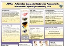 Automated Geospatial Watershed Assessment Tool |
EXPLORE MORE ON MPGIS |