The Need:
___________________________________________________________
Everybody associated with the Development in State, wheither from Government or Non-government and Private, needs ready Information. Be it Planning of Programmes and Selection of sites and locations, or Monitoring of activities during the implementation of programmes or the final evaluation of the impacts and results of the efforts, nothing may go without the support of appropriate information.
There is information available in pieces from odd number of sources, many of which are useful and outdated or unreliable. How can one depend and use them! If at all these are available from multiple sources, there is no uniform format.
We understand Maps easily:
___________________________________________________________
Man has the basic instinct to understand pictures and graphical information. The same rule applies even today also - not because we have got any weakness to understand the data, but because - 'No body has time to read thick volumes of Tables and go through voluminous Databases'.
 |
Maps have come in as the best form of presentation of information. Maps have a language that even a layman can understand. Obviously the educated class and the experts may go far beyond simple perception of data and may actually derive many useful conclusions easily which can bring lot of change in their day to day working mainly related to planning and monitoring activities.
|
It is thus, far more a useful medium than narrative form of information. And when put on computers, that is in digital form, the same maps become much more useful. The GIS techniques are used to computerise the maps - rather, computerisation of maps alongwith data generates a GIS. GIS is a commonly used system these days. Almost all field related works make use of GISs.
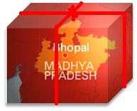
GIS: The MP GIS
___________________________________________________________
The state of Madhya Pradesh, that is India's second largest state, has large number of districts, blocks/talukas and villages and towns. The State has had the privilege of getting one of the first four projects in the country of Preparation of GIS under the auspices of Department of Electronics/ Min. of IT.Govt. of India, way back in 1995. A full fledged GIS centre was established at NCHSE, Bhopal and then began the work of fulfilling the GIS needs of the State from one to all.
MPGIS was created by NCHSE mainly keeping the needs of Mapped village level Information in mind. A village level GIS with units of Blocks/tehsils was prepared in 2004 under the support of DANIDA. |

The main components of MP GIS
___________________________________________________________
| - | Tehsil/Block Maps showing Village Boundaries; the Village are as polygons - for all villages of MP number over 54000. |
|
| - | Data of Census is attached to each village unit, which is viewable on simple click. |
|
| - | All this has been packaged in a user-friendly, custom deigned software to make the use of the information easy and meaningful. |
|
| - | Queries have been created which serve the purpose of planning, village identification, for projects and programmes etc. |
|
| - | All kinds of GIS processing such as map integration, superimposition, analysis, etc. leading to decision support. |
It is no more a dream to have ALL DISTRICTs' ALL BLOCKs' ALL VILLAGE maps ........ it is available now. ..................ASK US / contact us.
Perhaps you are missing something if you haven't used it until now.

The MPGIS Website :
___________________________________________________________________
This MPGIS website is another sincere effort by NCHSE just to support the needs of those who want to use GIS, want to learn GIS and see for themselves how useful it is!! You will see several useful pages on this site such as:
| - | Understanding GIS and browsing its uses and applications |
|
| - | Reaching out to important GIS websites for your GIS Software and services requirements |
|
| - | and also for availing ready guidance to apply GIS in your field related works of planning, monitoring, and evaluation. |
|
| - | There is no dearth of information on this MPGIS portal - if you want to truly equip yourself with knowledge and applying this simple technology - that is very common now-a-days. |
So read on ... and start using GIS - with ease and comfort.
___________________________________________________________________

 |
Applied GIS Training at NCHSE |
APPLICATIONS FOR GIS TRAINING PROGRAMMES ARE INVITED FROM INDIVIDUALS AND ORGANISATIONS. contact us ________________________ |
| L E A R N __G I S |
Download Free GISs Click Here. You may be interested to download Free GISs .... (go to GIS section on page opened) .spatialhydrology.com/freedownload.html |
 |