<< Go back

MP GIS

MP GIS
 
Home
GIS for you
Useful GIS
About us
Contact us


Health Information Management System

for Madhya Pradesh


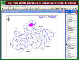
Madhya Pradesh is a populous State with a large number of villages.  Access to health facilities is very poor and the government's infrastructure is also limited and does not match the requirement any way. The health services also are not effective because of large geographic dimensions, poor connectivity and improportionate deployment of manpower and resources.

DANIDA, the Danish International Development Agency had been supporting Department of Health on resource development, training, family welfare (especially women and child) activities etc.  DANIDA and Health Department's higher authorities felt the strong need of compilation of up-to-date information from the field and realized this as the basic necessity to manage the huge infrastructure and the services associated. 
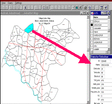
It was decided to develop a multifaceted database for the entire State covering information on health infrastructure, services, family programmes and the indicators of its impact. The information items to include were chosen as detailed information of all types of health service providers (individuals like qualified, nonqualified and traditional practitioners and government and private institutions) information on women such as pregnancy registration, ANCs, delivery, etc., information on children like births, birth rates, immunization etc.


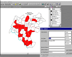
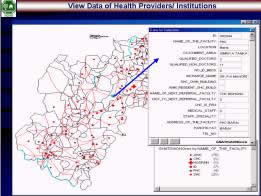
THE TASK: The entire state, all its villages and towns were surveyed and the job also included carrying out the computerization of the information, linking it to village maps and finally formulate a Geographic Information System on Health.


To make it easy to use the information for the Health Department's field functionaries, a special software was created for accessing and working with database. The package works on MapInfo.


When You Need

Micro- Level planning


in Health
Industry


HMIS

A village level
Health database on Madhya Pradesh maps


Thinking of
Assessing Health Infrastructure?
Area identification for Health services!! or
Marketing Medical products!!

Just Pick the Readymade GIS

'the HMIS on GIS'.
 

The District or village/town level information can be quite vital for planning your next step. Be it product launch or promotion of your health product, starting a Diagnostic centre or Opening Health centre,
here is the first Health Infrastructure Mapped Database on Madhya Pradesh: Of All Health providers, Hospitals, Labs, and what not...

Many databases are available but all are restricted to narrative lists, tables etc. The databases are also not easily perceptible to all – and often become the experts’ property. For commoners, for those needing the information in ready served format so that the same is put to effective use, quickly, the maps are the simplest medium.  And Maps put in an easy to install and simple to use package is most handy.

To make it easy to use the information for the Health Department's field functionaries, a special software was created under DANIDA's assignment for accessing and working with database.


  All the districts of the state are mapped showing the tehsils/blocks.
All the blocks further show the village boundaries.
The demographic data is also attached with the village-units
  The database can be queried and results be seen on the map itself highlighting the villages qualifying the condition of the query.Graphs are also simultaneously created for any field item from database. Graphs are also simultaneously created for any field item from database.
   
 
EASE OF OPERATIONS:
- The maps are opened simply from selection of the menu/submenu items.

- Alpha-indexed lists of the blocks and of villages appear for picking the name if one cannot recall its location on the map.

- Short cut menus appear with right click on the map screen.
  WHERE IT CAN BE USED !!
The package is most useful for the following:
- viewing the maps with village/town level data
- General retrieval of information on district, block and village level Health Infrastructure and services
- Modification of database and adding other information which makes it possible to orient the package for the needs of any specific theme.
- The database can be used for identification of areas matching any criteria and thus decision may start about further works: planning launching, promoting products, starting health services, etc.
  The database for the entire State covers information on health infrastructure, services, family programmes and the indicators of its impact. The information items include detailed information of all types of health service providers (individuals like qualified, nonqualified and traditional practitioners and government and private institutions) information on women such as pregnancy registration, ANCs, delivery, etc., information on children like births, birth rates, immunization etc.
 

Planning for projects/programmes can also be performed using the same
GIS based on socio-economic and other health related data:

 
The village maps are now superimposed with the health infrastructure mapping. These are poviders at each village - govt. and private. Attached data is also displayed alongwith.


The database may be queried to show the hatching on maps, making it helpful to assess the status of infrastructure and then plan.


For further details about the package contact NCHSE .... click here