|

The
Complete package for
Watershed Development Micro-Planning
|
|
The need:
"The
Watershed Development needs accurate planning. It needs planning
for variety of themes and features of the concerned area. The
planning is for development and it is most concerned with the
facts and features, at the current time and their
interrelationship and futuristic equation between the actions and
impacts of these many items." - Anonymous.
The
PIAs (Project Implementing Agencies) take the task of implementing
the Watershed programmes. The PIAs after collection of data have
to draw conclusions about the present features of the area, the
requirements and needs of the area and the people thereof, about
the activities as solutions for the problems, etc.
It requires a definite technique to use the data, to draw
conclusions and then take decisions about actions as remedy. No
pre-defined, pre-tested and easy to follow procedures exist (or
are not accessible to all), which could act as guidelines for the
PIAs to methodically exercise micro-planning for Watershed
Development. |
WHY THE PROCEDURE?
Not every one of
us would know:
q The
process of arriving at a fool proof action plan for Watershed development.
q As
to what information at what step helps the process of planning?
q From
which source, for what period/frequency, data is to be resourced?
q Which
maps can be combined/used for mutual updating?
q How
maps at different scales are combined/superimposed?
q How
information is transferred upto khasra level?
q When
to interact with villagers and how to use their inputs alongwith
technical information?
|
The Procedure:
The guidance procedure is prepared in written document form. The users
can take its advantage by adhering to the instructions in the
sequence, which are already most logically arranged. The users,
have to simply follow the activities mentioned, rather
mechanically and they are driven through till arriving at suitable
action plan. The process calls for a lot of mapped data
illustrations and the cartographic work needs a assisting tool
that is computer with CAD facilities. Hence it is customary to use
software here. A combination of the documentation and the software
is thus worked out for enabling an effective watershed planning.
The software developed is meant for assistance in the planning
process at several levels, and it basically acts as a tool for
accessing the CAD functions related to the cartographic works. The
software helps the total process of data recording into the
computer, the illustration on maps, integration of maps, analyses,
and eventually arriving at the to be proposed action plan for
treatment activities for the watershed development. The unique
feature is that the planning process sees a balanced use of
scientific approach and villagers involvement to ensure that all
the planned activities are technically viable and socially
acceptable. A proper use will not only help and guide the user
through the process, but it may lead to help achieve even that,
which is beyond the scope of the here described planning technique. |
Important features
- Complete stepwise procedure.
- Detailed documentation supported.
- Built in automation at several steps.
- First of its kind bringing technical information to khasra
(village) map.
- Necessitates field and villagers' inputs. |
Other
Built-in Modules
· A full fledged glossary module on Watershed related terms.
· Papers/documents from Watershed experts.
· Multimedia based educational modules.
· Support material for conducting PRA in villages. |
Details of Features of the Procedure:
1. Complete stepwise Procedure to Plan Watershed Development.
2. Designed under guidance of experts of Watershed, and
experienced PIA (Project Implementing Agency) representatives.
3. Information from maps of various scales all brought to common
scales.
4. Information finally transferred and made available at Khasra
(micro) level.
5. Does include scientific information from Remote Sensing,
thematic maps, secondary sources, etc.
6. Automatic scale alteration and map merging at various stages.
7. A full fledged CAD package works in background; may be accessed
any time for any CAD utility.
8. Appendices included to detail any sub-procedure or to discuss
methodology of important technical steps and field level works.
9. Includes a sophisticated Glossary package for ready references.
10. Includes standard Multimedia based, self explanatory, small,
subject based educational documentaries for field staff and
villagers.
11. Includes standard PRA support material to enable easy field
working.
12. Requires simple PC and occasional peripheral support as
hardware, that too for short duration. |
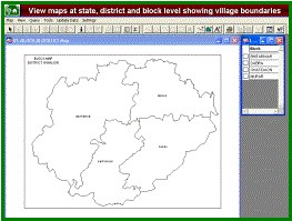
LAYOUT OF
THE PROCEDURE DOCUMENTATION
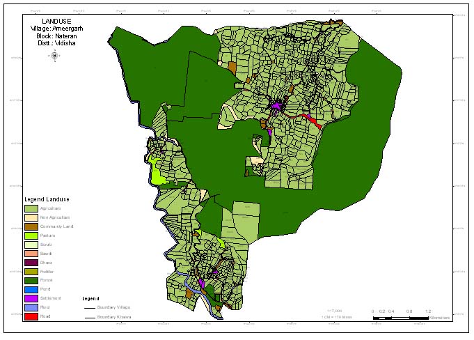
MODULE I: Basic Maps Preparation The first module deals with basic
map preparation. These maps are all at small scales of 1:250,000
or 1:50,000 and are made from Survey of India toposheets and from
remote sensing products. This module achieves the 'map base'
preparation showing themes at village level and are prepared for
miliwatershed unit.
MODULE II: Updating Maps, Scale Alteration & Analysis This
module deals with mutual updation of the maps prepared in previous
module and also performs few integration and analyses, exercises.
This module also alters the scales of all maps to 1:12,500.
MODULE III: Microwatershed Level Works The module, uses the maps
produced in previous module and allows them to be transferred to
Khasra maps. Micro watershed level works. It helps arriving at
several decisions regarding identification of treatment measures
and suitable sites for these. The participation of the villagers
is also ensured here. Action plan is prepared and finalised here,
as per the actual ground level requirements and the consent of the
villagers.
|
HOW TO
USE THE PROCEDURE:
The procedure is
provided under a package of written documentation and software.
The document describes all steps for the entire process from
beginning to end. All steps are arranged in logical order and
therefore, these have to be followed in the same sequence. The
document mentions steps to be performed manually and on computers
and thus, it states clearly where and how the computer software
has to be used. The users would keep on switching between the
manual process and computerised processes alternately.
WHO CAN USE THIS PROCEDURE:
Users of the procedure are the Watershed implementing agencies. As
such, there is no minimum specified qualification, or skill
required to use this procedure, but it is expected that the user
should be a team of individuals from various subject matters. The
team should comprise of:
· Person(s) should be thoroughly familiar with watershed
programme and all its components. · Person(s) should have
knowledge of computers and cartography. Regarding computers, the
knowledge of Auto CAD software is essential. There is definite
need of manual mapping also. · Person(s) familiar with remote
sensing data interpretation are required at certain points. ·
Field investigators to carryout field surveys and to collect data.
· At certain times, access to experts (visiting) will be desired,
from disciplines such as hydrology, agriculture, forestry, civil
engineering etc
|
|
|
|
|

|
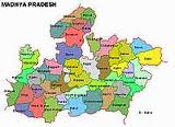
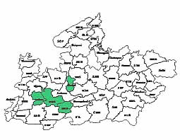
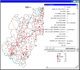
MIS for
Village Planning
(developed for UNICEF)
|
|
A pcakage for the houshold level information on health and family welfare activities indicators created for two districts of Madhya Pradesh - Guna and Shivpuri which has the general village level statistics.The
database is encapsuled in software, which is a user-friendly
interactive set of programmes, specially designed for retrieval and use
of the information. Broadly, the system shall offer the following
features.
| |
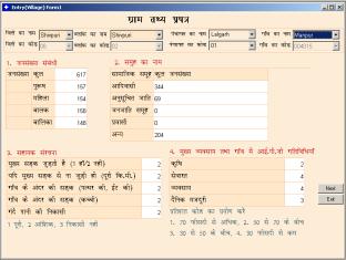
Village level data on General Information, Demographic Profile,
Ethnographic details, Support infrastructure, Key Occupation & IGP
activities in village, Market/Haat details, Public Offices/ Services in
village, Basic Services & Service infrastructure, Available human
resource in village will be available.
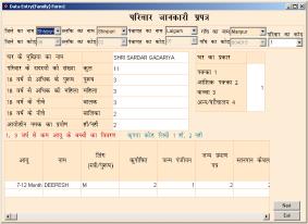
Similarly another set of data Household wise, based on Information/ Data
Sheet of family, Details of children below 3 years of age, 3-6 Years,
6-14 years, 14-19 years, Household information Sheet, Family death
information are available.
|
|
 |
| |
|
|
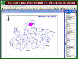
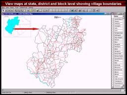
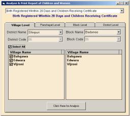
Block level and district
level summary would be generated. The package will have simple selection
facility to choose village, blocks and district as unit. |
| |
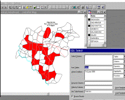
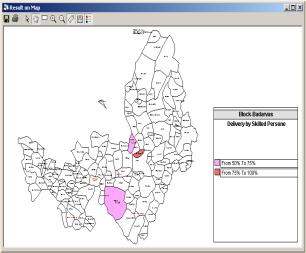
There is also be facility to analyse data on different parameters. There is a set list of queryanalysis items to choose form. Simple to clubbed queries can be performed.
|
|
 |
| |
 |
|
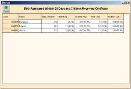
There is also a report
format built to view the data. Together, here
is also be a facility available to see the results in form of graphs
such as line, bar or pie depending upon best suiting presentation. |
| |
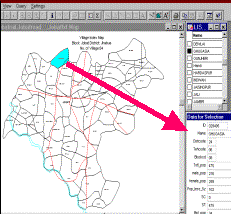
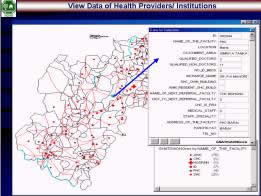
The main feature of the package is to view data on maps at village
level. Even the query analysis outputs can be seen on this.
The software may export data to other formats such as excel, Access or
other database packages as well as SPSS. Thus, onward analysis can also be done in other statistical
packages.
|
|
|
| |
The package offers another
useful feature of updating the data format and minor other software items from time to time and thus the whole
system is quite flexible. This feature can be best utilized to include
other sectors’ data in to the package that the some village level data
can be expanded for additional fields. |
|